|
A Journey To Our Nation's Capital: Washington D.C A Social Studies Webquest for 5th Grade
By
Introduction
| Learners
| Standards
| Process
| Resources
| Evaluation
| Conclusion
| Credits
| Student
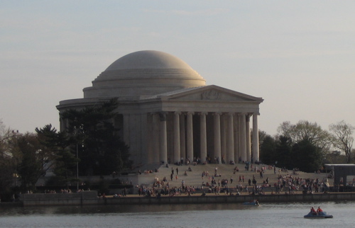
Page This lesson is part of a geography unit focusing on physical characteristics of regions, cities, applying mapping techniques, geography vocabulary (scale, movement, distance, location), and how humans are affected by their physical environment. It is a multidisciplinary lesson that includes geography, writing, reading, website research, American history, and math. This lesson provides students the opportunity to use their geographic knowledge of a location, reading ability, research skills, understanding of history, and mathematics to increase their understanding of Washington D.C. This lesson enables the teacher to build off what students learn about Washington D.C. and apply it to other places around the world for future geographic lessons within the unit. This lesson provides the opportunity to explore a place that many will have never been, learn about the environment, the history, the physical characteristics, the movement of people, and how humans activities have adapted to the environment. There are many things relating to geography that can be found in Washington D.C. For example, Washington D.C. borders the Tidal Basin, the Potomac River, the Washington Channel, Kingman Lake and the Anacostia River. This lesson emphasizes the application of geography vocabulary, the ability to locate and identify geographic features of a location, and understanding of a physical environment to virtual exploration of a real location. This lesson is designed for fifth grade geography and social studies. The students will be able to do map work, identify Washington D.C. as geographic location, describe the physical environment, create mathematical calculations of distance, and journal writing. Curriculum Standards Objectives:
Benchmarks: Oregon Standards 2006-07 Students are encouraged to explore Washington D.C. and create their own opinions about what aspects of the city are of interest to them. Students should apply their knowledge of geography (map use, physical land characteristics), cultural aspects (people, buildings, urban environment, art), and compare how Washington D.C. to other cities (or their home). If students choose to work in teams, they should decide as a team what places are worth exploring and come to a consensus for why they decide to explore a particular place within Washington D.C. Step 1: Work individually or with a group to explore Washington D.C. Figure out where you are going. Start by answering these questions: Keep record of your findings in a journal. Washington D.C. Characteristic Questions:
http://maps.mapnetwork.com/dc/wctc/index.asp http://maps.google.com/ (search Washington D.C.) http://dcpages.com/History/DC_Name_History.shtml http://www.infoplease.com/ipa/A0108620.html http://www.infoplease.com/ce6/us/A0861877.html  http://www.ace-clipart.com/ *Beginning Exploration.
Step 2: The next step is for students to figure out how to get around. Start by finding a map that leads you to the many places around and within Washington D.C.. Many people take the metro to get around. What is the Metro?
Step Step 3: Now that you have your map ready and you know how to get around, it is time to explore.
Pick six museums to explore and create a journal entry for each.
This lesson will take students three to four hours to complete. It should be spread over two-three days in the social studies segmented class time. Because this lesson is part of a unit, the teacher will decide how to allocate time for the students' completion of the webquest requirements. This lesson includes geography, writing, computer use, reading, and basic mathematics when calculating distance between cites. Students will have the option
of working in groups. Students will be able to decide their own groups if they want.
Students can work individually if they want, but it will depend on the
number of computers available. The only issues that
could occur is the students ability to focus on the lesson and its
requirements. Students will need to stay focused, and be productive
during the class time provided if they are to finish in within the time
allocated. The required
abilities a teacher should have is basic computer geography knowledge.
A teacher needs to know how to turn on a computer, access the Internet,
and load the webquest for students. The teacher should have a basic
understanding of geography, and navigation abilities. The teacher
should be able to comfortably search the web for a topic of interest. Computers available for each student with internet access. Use of Safari, Firefox, Netscape, or other internet search. There should be enough computers for each student to use one, or enough chairs around a work station for a group of 2-3 to share. Each student should have a notebook to use for journal or eight pages for notes and entries. Website Links:http://maps.mapnetwork.com/dc/wctc/index.asp http://maps.google.com/ (search Washington D.C.) http://dcpages.com/History/DC_Name_History.shtml http://www.infoplease.com/ipa/A0108620.html http://www.infoplease.com/ce6/us/A0861877.html Metro Links:
Smithsonian: http://www.si.edu/
This lesson only requires one teacher to be present while students explore the webquest. The teacher's role is to clarify and answer questions about the assignment for students. The teacher will make sure students are on task, and keep them looking at the appropriate websites for the lesson. The lesson will be successful if the students are able to navigate smoothly through the webquest. Students will demonstrate, and be evaluated on their ability, to apply their knowledge of maps, physical geography, location, direction, distance, scale, movement, and visual representations distinguishing features (physical and human) of place descriptions in their journals. Evaluation will include the quality and quantity of descriptions of cites visited in their journal. Students will be evaluated on their ability to create an organized journal with the required questions answered. Students will be evaluated on their ability to find a map with their cites visited marked, the route take, and the distance traveled between each place. Students will evaluated on their use of geography vocabulary in their journal, and provide accurate descriptions surrounding Washington D.C..
This lesson will provide
students an opportunity to apply their geography knowledge of maps,
location, distance, physical environment, scale, region, and human
activities affected by a physical environment to a major US city. The
knowledge and process used in this webquest lesson can be applied
to future geographic studies of cities and regions around the globe. In
class, students will be able to share their journals and experiences
with their peers after completing the webquest. Students will be able
to develop a refined understanding of Washington D.C's geography and
attractions through a variety of experiences from classmates.
Smithsonians: http://www.si.edu/
http://maps.mapnetwork.com/dc/wctc/index.asp THANKS TO: Mark Bailey for providing the template and information for how to complete this webquest. |